Quebec Public Lands Subscription
The Quebec Public Lands subscription includes 7 different map layers: Provincial Crown Land, Private Land, Park, Outfitter, Municipality, Regional County Municipality, and Trail boundaries.
To use these layers on your map, first make sure you have iHunter QC:


Then either try it free for 3 days or subscribe for only $9.99 per year to benefit from the layers being updated annually.
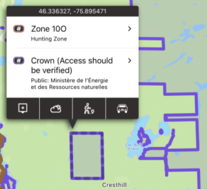
Provincial Crown Land
92% of Quebec is made up of public land, and the vast majority of this land is publicly accessible. There may be additional access and discharge restrictions on this land that are not documented in openly available GIS layers, and it is the user’s responsibility to obey all posted restrictions in the field. The cartographic representation of the private or public nature of land and authority is constructed from archived data from the old Terrier register (SITAT), requests for transfers of authority, state property transactions and the integration of data from the cadastre of Quebec. On the other hand, this representation does not take into account certain reservations established by law (three chains, borders, paths, beds of watercourses, etc.). Consequently, this representation has no legal value, and it is always necessary to refer to the deeds or to the letters patent and to apply the law in order to determine the ownership of a portion of the territory.
These areas are shown in purple on the map, and are built into the app. They can be used even without cell coverage.
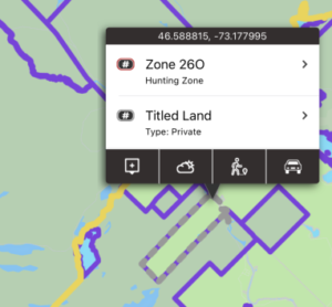
Private Land
Although making up only 8% of land in Quebec, private land is important because permission is required to access it.
These boundaries are downloaded ‘on the fly’ as you view that portion of the map. An Internet connection is required the first time that area and zoom level is viewed. You can pre-cache regions of this layer by using the Manage Cache button (Add Region to Cache). These areas can also be tapped on to display additional information including the acreage of the property. Tapping for more info does require internet access.
Parks
The Parks layer includes the boundaries for National Parks, Provincial Parks, and Regional Parks. Hunting is not permitted in any Québec park, however fishing may be permitted.
These areas are shown in dark red on the map, and are built into the app. They can be used even without cell coverage.
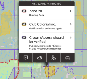
Outfitters
Outfitters with exclusive rights are outfitters that have exclusive wildlife exploitation rights in a given territory, under an exclusive rights lease arrangement with the Ministry, for hunting and/or fishing and/or trapping. The designated territory is subject to a specific Wildlife Trust agreement and only the outfitter’s clients are permitted to hunt, fish or trap within that territory. The representation of this territory has no legal claim. Only filed documents have the force of law.
These areas are shown in dark yellow on the map, and are built into the app. They can be used even without cell coverage.
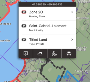
Municipalities
Municipalities have the authority to enforce shooting and hunting restrictions within their jurisdictions. By having these boundaries mapped, you can assess whether you are within the municipal boundary and subject to its bylaws.
These areas shown in dark grey on the map, and are built into the app. They can be used even without cell coverage.
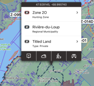
Regional County Municipalities
Regional County Municipalities are for information purposes only and shouldn’t have any effect on hunting seasons or rules.
These areas shown in navy on the map, and are built into the app. They can be used even without cell coverage.
Trails
The Trails layer includes a compilation of trail networks including: Snowmobile trails (CUGR), Snowmobile trails (FCMQ), Snowmobile trails (White Route), Quad bike trails (CUGR), Quad bike trails (FQCQ), Hiking trails, and Archery trails.
These trails are shown as light grey dotted lines on the map. These boundaries are downloaded ‘on the fly’ as you view that portion of the map. An Internet connection is required the first time that area and zoom level is viewed. You can pre-cache regions of this layer by using the Manage Cache button (Add Region to Cache).