Manitoba Public Lands Subscription
The Manitoba Public Lands subscription includes 8 different map layers: Public Lands Subscription which includes 8 different layers: Huntable Public Parks, Hunting Restricted Lands, Provincial Forest, Community Pastures, Public Shooting Grounds, Private Conservation Lands, Property Boundaries and the Northern Theoretical Grid.
To use these layers on your map, first make sure you have iHunter MB:


Then either try it free for 3 days or subscribe for only $14.99 per year to benefit from the layers being updated annually.
Property Boundaries
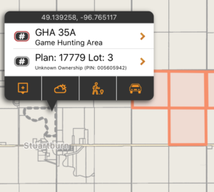
Knowing the size and shape of a piece of land makes it easier to discuss with landowners, and being more informed could help with obtaining permission. This layer shows the cadastral boundaries and legal land description information (which can be used to pull land titles). Properties can be tapped on to display the property’s PIN, Acreage, Legal Description, and more. Tapping for more info does require internet access.
These boundaries are shown in grey on the map and downloaded ‘on the fly’ as you view that portion of the map. An Internet connection is required the first time that area and zoom level is viewed. You can pre-cache regions of this layer by using the Manage Cache button (Add Region to Cache).
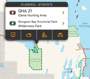
Huntable Public Parks
This layer includes the boundaries (and additional information about) Wilderness Parks, Indigenous Traditional Use Parks, Park Reserves, and Natural Parks that allow hunting. Specific rules for both access and hunting may exist. When possible, links to additional content are provided for the specific areas.
These areas are shown in green on the map, and are built into the app. They can be used even without cell coverage.
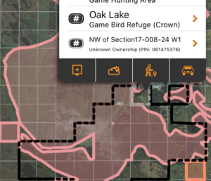
Hunting Restricted Lands
Some land designations forbid hunting by definition. Those area designations included in this layer include some Provincial Parks, Ecological Reserves, National Parks, Wildlife Refuges, Game Bird Refuge, Goose Refuges, Furbearing Animal Refuges, Natural Parks, and Nature Manitoba lands.
This is not a complete listing of every parcel of land the dis-allows hunting, as that is an impossible task. It is merely a visualization of the defined hunting restricted areas as listed above. No-hunting zones described in the Hunting and Trapping Regulations, which do not have digital boundaries published by the province, are not included in this layer.
These areas are shown in red on the map, and are built into the app. They can be used even without cell coverage.
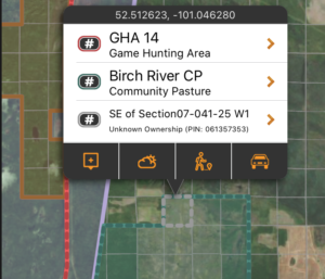
Community Pastures
This layer shows the boundary of the Manitoba Community Pastures. Hunting on community pastures is permitted at times, according to specific conditions (which are listed within iHunter).
These areas shown in teal on the map, and are built into the app. They can be used even without cell coverage.
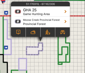
Provincial Forest
This layer shows the boundary of the Manitoba Provincial Forests. Most areas of the Provincial Forest allow hunting and recreational access.
These areas shown in purple on the map, and are built into the app. They can be used even without cell coverage.
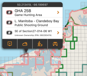
Public Shooting Grounds
Public Shooting grounds are crown lands, established almost a hundred years ago, and provide hunting opportunities for all hunters.
These areas shown in pink on the map, and are built into the app. They can be used even without cell coverage.
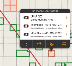
Private Conservation Lands
Many parcels of private land are owned by Conservation organizations such as Ducks Unlimited Canada, Manitoba Habitat Heritage Corporation, Nature Manitoba and Nature Conservancy of Canada. This layer maps and lists these properties with instructions on how to contact them for inquiries.
Public access varies from organization to organization, and the user is responsible for determining access by contacting the conservation organization.
These areas shown in orange on the map, and are built into the app. They can be used even without cell coverage.
Northern Theoretical Grid
Northern Manitoba is primarily Crown Land that has not been surveyed and parcelled out like the rest of the rest of the province. It can still be helpful to think of the area split into Quarter Sections and Sections, so the Northern Theoretical Grid layer splits the Northern Area into Quarter section parcels, addressable like the rest of the province’s reference grid.
These boundaries are shown in grey on the map and downloaded ‘on the fly’ as you view that portion of the map. An Internet connection is required the first time that area and zoom level is viewed. You can pre-cache regions of this layer by using the Manage Cache button (Add Region to Cache).