Saskatchewan Public Lands Subscription
The Saskatchewan Public Lands subscription includes 5 different map layers: Provincial Forest, Fish and Wildlife Development Fund Land, Huntable Public Parks, No-Hunting areas, and Municipalities.
To use these layers on your map, first make sure you have iHunter SK:


Then either try it free for 3 days or subscribe to the Saskatchewan Public Land layers for only $9.99 per year so you’re always up to date.
map layer
Provincial Forest
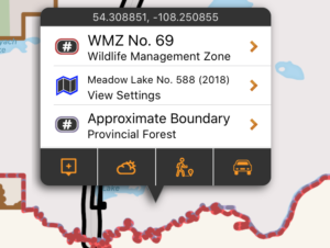
This layer shows approximate boundary of the Saskatchewan Provincial Forest. Most areas of the Provincial Forest allow hunting and recreational access.
Be aware that there are pockets of private land, provincial parks, agricultural lease land, reservations, and other land types that may prevent access. Always use other sources of information such as on-site signage, fencing and other maps to make decisions on access. Use this boundary as a guideline only, as the Province is currently updating this boundary to be more accurate.
These boundaries are shown in pale purple on the map, and are built into the app as part of the subscription. They can be used even without cell coverage. Tapping on the area will give additional information about the selected land.
map layer
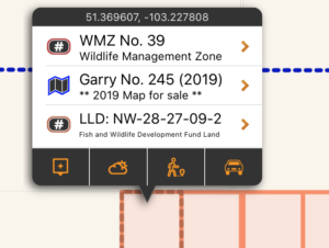
Fish & Wildlife Development Fund Lands
Wildlife lands are not reserves or sanctuaries. These natural areas have been bought with your hunting and trapping dollars, and can be used by everyone. Naturally, hunting is allowed on these lands. Lands are also open to other outdoor nature enthusiasts, including hikers, bird watchers and photographers.
There are four main rules when visiting FWDF lands:
- Walk-in traffic only (except when retrieving big game during hunting season)
- Walk-in camping only – no open fires;
- No littering;
- and No interference with an authorized management treatment (e.g., haying or grazing).
These boundaries are shown in orange on the map, and are built into the app as part of the subscription. They can be used even without cell coverage. Tapping on the area will give additional information about the selected land.
map layer
Huntable Public Parks
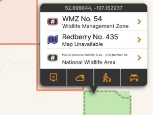
The Huntable Public Parks layer is made up of three types of public land that are all accessible and allow hunting: National Wildlife Areas, some Provincial Parks, and some Recreation Sites. Some areas have special restrictions such as firearms limitations or restricted areas, restricted hunting seasons, etc. In general, they all allow hunting in some form.
These boundaries are shown in pale green on the map, and are built into the app as part of the subscription. They can be used even without cell coverage. Tapping on the area will give additional information about the selected land.
map layer
Municipalities
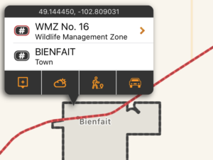
Municipalities have the authority to enforce shooting and hunting restrictions within their jurisdictions. By having these boundaries mapped, you can assess whether you are within the municipal boundary and subject to its bylaws.
They are shown in dark grey on the map, and are built into the app as part of the subscription. They can be used even without cell coverage. Tapping on the area will give municipality name and type.
map layer
No Hunting Areas
Some land designations forbid hunting by definition. Those area designations included in this layer include Ecological Reserves, National Parks, Migratory Bird Sanctuaries, Game Preserves, Wildlife Refuges, and some Provincial Parks and Recreation Sites.
This is not a complete listing of every parcel of land the dis-allows hunting, as that is an impossible task. It is merely a visualization of the defined no hunting zones as listed above. No-hunting zones described in the Hunting and Trapping Regulations, which do not have digital boundaries published by the province, are NOT included in this layer.
They are shown in black on the map, and are built into the app as part of the subscription. They can be used even without cell coverage. Tapping on the area will give the Park name and designation.